Cover Page
             Coastal Processes with Engineering Applications

Robert G. Dean
Robert A. Dalrymple
Graduate Research Professor
Department of Civil and Coastal Engineering
University of Florida
Gainesville, FL, 32611
Hackerman Professor
Department of Civil Engineering
Johns Hopkins University
Baltimore, MD 21218

Cambridge University Press, 2002
488 pages,   ISBN: 0521495350
Note: it is only available in paperback now: ISBN 0521602750


Description:     This text is an upper level introductory text to coastal processes and engineering approaches to beach erosion.  The conceptual model of an equilbrium beach profile is used to determine the response of beaches to relative sea level rise and storms, and to assess the amount of sand to be added in a beach fill.  Topics such as tidal inlets, coastal modeling, and sediment transport are included to cover much of the field of coastal engineering.


Study Aids:

        Java Applets:  There are a number of Java applets available on the web for use with the textbook.  The location is
                                      www.coastal.udel.edu/faculty/rad


          Introduction
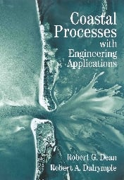
                         Examine the cover of the book, which is an aerial photograph of Redfish Pass on the west coast of Florida. The pass separates North Captiva Island from Captiva Island (bottom of photo). The Gulf of Mexico is on the left side of the photo and Pine Island Sound is to the right.  Discuss the features visible in the photo.

                         Note the difference in the shoreline at both sides of the pass.  Where is the sand accreting?  Notice how the shoal patterns in the Gulf of Mexico differ from those in the bay. Look at the wave direction.  Where has sand overwashed?  Look for the dredged channels.
         

Errata:
Chapter 1
Chapter 2
Fig. 2.5: Ordinate is "Grain Size (mm)" Fig. 2.7: Water temperature curves should be labelled as 0 degrees C for the upper curve increasing by 10 C per curve to 40 degrees C on the bottom.
Chapter 3
P. 44, first footnote: 1987 should be 1988 in reference.
p. 66, The reference of Suh and Dalrymple should be replaced by: Suh, K.D., and R.A. Dalrymple, "Expression for Shoreline Advancement of Initially Plane Beach," Waterway, Port, Coastal, and Ocean Eng., Reston, VA: ASCE, 114, 6, 770-777, 1988.
Chapter 5
p. 93, 7th line: 1984 should be 1983.
p. 98, Eq. 5.19, h/Hb should be h/hb twice
p. 98, Eqs. for α and β : Hb/Hb should be hb/Hb
p. 98, Eq. 5.20. h/Hb should be h/hb
p. 102, Eq. 5.32. Hb should be hb
p. 103, Eq. 5.33, first term (h+ η) should be (h+overbar(η))
Chapter 7
Example 1:  tan (β) should be tan (θ).
Chapter 8
Eq. before 8.57, gs(y) should be qs(y) ; that is, g -> q
Chapter 12
Fig. 12.12; Ordinate is R/Ro.
Additional Materials


Problems

          Chapter 10
                         
Sand mining has resulted in a cut into the beach planform 100 m wide and 1000 m long. How would you model the shoreline evolution? Sketch the shoreline positions with time as the cut fills naturally. How would you calculate the time it takes for the indentation to fill in 50%?
          Chapter 11
                          A beach fill is placed on a beach with a berm height of 1 m and a slope of 1:10. Using the equilibrium beach concept, show that the equilibration recession is 72 m, if the berm height is 1 m, the width of the active profile is 210 m, and h_* is 7 m.
          Chapter 12
                         Two fixed headlands are build on a straight shoreline, separated by 1000 m. If the wave angle of incidence is 20 degrees (updrift) from the original shore normal, what is the subsequent equilibrium planform according to Hsu, Silvester, and Xia (1986)?